Makalu Base Camp Trek in 19 Days

15 Reviews in TripAdvisor
36 Reviews in Google

The Makalu Base Camp Trek takes you to the foot of Mt. Makalu (8,463 m), the fifth-highest mountain in the world, through the remote Makalu Barun National Park in eastern Nepal. This 19-day teahouse trek starts and ends in Kathmandu, flying in and out via Tumlingtar. The route is quiet, the lodges are basic, and the landscapes shift dramatically from subtropical forests to glacial terrain. Our team has completed this route and what we can tell you is that the effort and the reward are well matched. [Coordinates: 27.8900° N, 87.0881° E]

Grade: Strenuous

Trip Overview
Duration19 Days
Trip GradeStrenuous
CountryNepal
Maximum Altitude4,870 m
Group Size1-20
StartsKathmandu
EndsKathmandu
ActivitiesTrekking
Best TimeMarch - May, October - December

TREK HIGHLIGHTS

  • Stand at Makalu Base Camp (4,870 m) directly beneath Mt. Makalu (8,463 m), the fifth-highest peak in the world, with views of Baruntse, Chamlang, and on clear days Everest and Lhotse.
  • Cross Shipton La (4,127 m) and Keke La (4,170 m) on the same day, with a glacial lake between the passes and wide mountain panoramas from the top.
  • Trek through Makalu Barun National Park, home to over 440 species of birds and wildlife such as red panda, snow leopard, and Himalayan tahr, though sightings are rare.
  • Walk through remote Rai villages in the lower valleys and high-altitude Sherpa settlements higher up, two completely different cultures on a single route.
  • Trek on a quiet teahouse route with a fraction of the crowds found on Everest or Annapurna trails.

19-Day Makalu Base Camp: What to Expect?

This 19-day Makalu Base Camp Trek takes you deep into the Makalu Barun National Park, through remote Rai villages, dense rhododendron forests, high-altitude Sherpa settlements, and two dramatic passes before placing you at the foot of the world's fifth-highest mountain, Mt. Makalu.

The trails are quieter, the landscapes are wilder, and the physical demand is real. Expect long days, steady altitude gain, and limited facilities above Tashigaon. But in return, you get a raw Himalayan experience that very few trekkers ever reach!

Continue reading this package to learn what our team at HEN has got for you in our books. And once you're satisfied, book this package with us!

Main Attractions of the Makalu Base Camp Trek

From glacial passes to rare wildlife corridors and remote cultural villages, here is what makes this trail genuinely unlike anything else in Nepal:

Makalu Barun National Park: The Off-beaten Trekking Region

The park covers most of the upper route and holds some of Nepal's richest biodiversity. It protects 25 of Nepal's 30 species of rhododendron, 47 types of orchids, and 87 species of medicinal herbs.

Wildlife includes red panda, snow leopard, Himalayan black bear, Himalayan tahr, musk deer, and wild boar. Over 440 species of birds have been recorded here.

The mid-altitude forest sections offer a chance to spot the most common wildlife, such as red panda and Himalayan tahr.

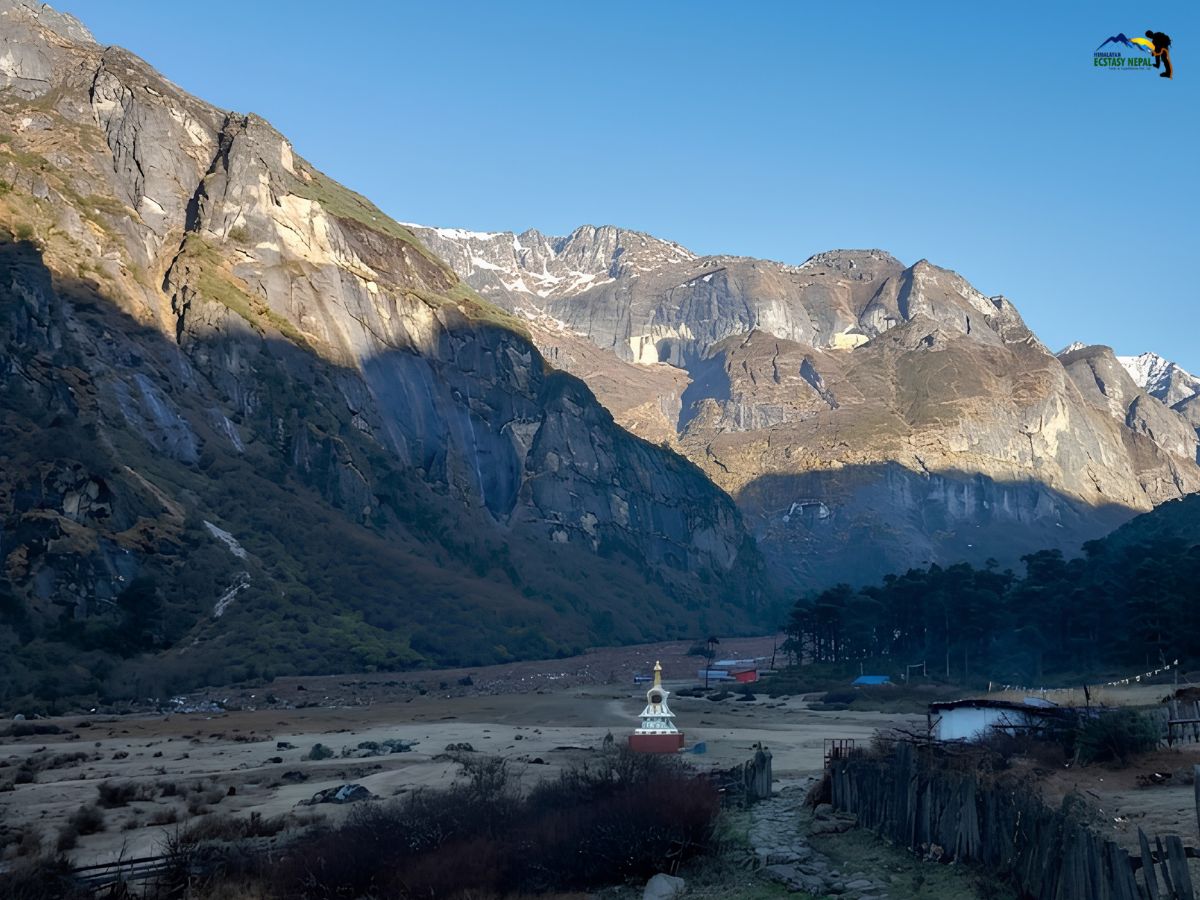
The Barun Valley: Amazon of the Himalayas

The upper Barun Valley from Yangle Kharka onward is designated Nepal's first "Strict Nature Reserve".

The landscape opens into wide yak pastures, glacial streams, and rocky moraine with high peaks closing in on all sides.

Very few trekkers reach this section, and that remoteness is a defining part of the experience on this route!

Makalu Base Camp at 4,870 m: A Hidden Paradise!

This is where everything leads. You stand at the foot of Mt. Makalu's south face looking up at a wall of ice, ridges, and seracs that is hard to fully take in.

On clear days, Baruntse (7,129 m) and Chamlang (7,319 m) are also visible, and in ideal conditions, Mt. Everest and Mt. Lhotse also appear on the distant horizon!

An extra ridge hike from camp takes around three hours return and opens wider views of the surrounding peaks and the Barun Glacier below!

Shipton La (4,127 m) & Keke La (4,170 m): High Passes in Makalu

Both passes are crossed on the same day in the most dramatic stretch of the trek. Between them sits Kalo Pokhari, a small glacial lake at around 4,000 m with prayer flags marking the tops of each pass.

Shipton La is named after British explorer Eric Shipton, whose early expeditions helped map this part of the Himalayas. Views from the top across the Makalu range are broad and impressive on a clear morning!

Learn Rai and Sherpa Village Culture

The lower trail passes through Rai villages where terraced farmland, cardamom fields, and bamboo groves line the path.

Higher up, Sherpa settlements appear with monasteries, mani walls, and prayer flags. Both communities are welcoming, and the transition between them happens gradually and naturally as you gain altitude each day.

Why Makalu Base Camp Trek with Himalayan Ecstasy?

  • We arrange both required permits before your trek begins so there are no delays at any checkpoint.
  • We provide a licensed guide who has completed this route and understands the terrain and acclimatization demands of the upper Barun Valley.
  • We organize all jeep transport between Tumlingtar and Num using reliable local vehicles.
  • We provide porter support on a one-porter-per-two-trekkers basis.
  • We carry an emergency basic first aid kit throughout the trek.
  • We coordinate teahouse bookings in the entirety of Makalu region, including the limited options at higher elevations.

Makalu Base Camp Trek in 19 Days Itinerary

Kathmandu to KathmanduExpand all

This is rest and prep day! Our HEN representative meets you at Tribhuvan International Airport and transfers you to your hotel in Thamel.

In the evening, our team holds a short briefing to walk you through the itinerary and introduce your guide!

Max Altitude: 1,400 m Meals: DinnerAccommodation: 3-Star HotelTransportation: Private vehicle

HEN completes your permit arrangements in the background while your day stays free. Visit Pashupatinath Temple, Boudhanath Stupa, Swayambhunath, or Kathmandu Durbar Square.

Pick up any last-minute gear in Thamel before your guide does a final kit check in the afternoon.

Max Altitude: 1,400 m Meals: BreakfastAccommodation: 3-Star Hotel

Your travel day begins today! The morning flight east to Tumlingtar takes around 35 to 40 minutes and can give clear views of Mt. Makalu and Mt. Kanchenjunga on a good day.

From Tumlingtar, a jeep ride of 4 to 5 hours through terraced hillsides and small settlements brings you to the ridge town of Num, where trekking begins tomorrow!

Max Altitude: 1,560 m Meals: B, L, DAccommodation: Local LodgeTransportation: Flight and Jeep
  • Route: Num > Chamla Kharka > Seduwa
  • Walking hours: 5 to 6 hrs
  • Distance: 7 km approx.
  • Elevation gain: 60 m approx.
  • Highlight: The day begins with a steep drop through terraced cornfields to the Arun River suspension bridge, then climbs steadily to Seduwa. The national park entry checkpoint is here, and your permits will be checked. Start early, as the lower sections are warm and humid.
Max Altitude: 1,500 m Meals: B, L, DAccommodation: Local Lodge
  • Route: Seduwa > Chyakse Danda > Tashi Gaon
  • Walking hours: 4 to 5 hrs
  • Distance: 8 km
  • Elevation gain: 570 m
  • Highlight: A gradual climb through terraced farmland and rhododendron and bamboo forest. Tashi Gaon is the last permanent village before the national park and the mountains take over. In spring the rhododendrons on this section are in full bloom
Max Altitude: 2,070 m Meals: B, L, DAccommodation: Local Lodge
  • Route: Tashi Gaon > Dhara Kharka > Kauma La Pass > Khongma Danda
  • Walking hours: 6 to 7 hours
  • Distance: 6.5 km
  • Elevation gain: 1,430 m
  • Highlight: One of the hardest climbing days on the trek, as it's uphill. The trail ascends steeply through thick rhododendron and pine forest with very few flat sections. Take it slow and rest when needed. The first proper mountain panoramas open near the top of Khongma Danda.
Max Altitude: 3,500 m Meals: B, L, DAccommodation: Local Lodge

Today will be a rest day with just a short walk. Your guide leads a short uphill walk above the lodge, following the principle of climbing high and sleeping low.

On a clear morning, views toward the Kanchenjunga range are visible from the ridge above camp.

Max Altitude: 3,500 m Meals: B, L, DAccommodation: Local Lodge
  • Route: Khongma Danda > Ghungru La > Sano Pokhari > Shipton La > Kalo Pokhari >  Keke La > Dobate
  • Walking hours: 6 to 7 hrs
  • Distance: 7.5 km
  • Elevation gain: 150 m
  • Highlight: The most dramatic day of the ascent. You cross both high passes in one push with the glacial lake of Kalo Pokhari sitting between them and prayer flags marking the tops of each. Views from Shipton La across the Makalu range are broad and impressive on a clear day. Crampons may be needed if snow is present on the passes.
Max Altitude: 3,650 m Meals: B, L, DAccommodation: Local Lodge
  • Route: Dobate > Mumbuk > Phematang > Yangle Kharka
  • Walking hours: 8 to 9 hrs
  • Distance: 9 km
  • Elevation Loss: 93 m
  • Highlight: A more relaxed day after the pass crossing. The trail descends through rhododendron forest to the Barun River, then follows it upstream through a widening valley. A small monastery near Yangle Kharka makes for a memorable photograph with snowy peaks rising behind it.
Max Altitude: 3,557 m Meals: B, L, DAccommodation: Local Lodge
  • Route: Yangle Kharka > Nghe Kharka > Tadosa > Langmale Kharka
  • Walking hours: 6 to 7 hrs
  • Distance: 8 km
  • Elevation gain: 853 m
  • Highlight: A long, steady climb through the upper Barun Valley past yak pastures and herder huts. By arrival at Langmale Kharka, a mani wall with prayer flags sits just in front. Go slowly and drink plenty of water on this day!
Max Altitude: 4,410 m Meals: B, L, DAccommodation: Local Lodge
  • Route: Langmale Kharka > Merak > Sherlali > Makalu Base Camp
  • Walking hours: 8 to 9 hours
  • Distance: 8.5 km
  • Elevation gain: 460 m
  • Highlight: The trail crosses glacial moraine and boulder fields before opening at base camp, right near the Upper Barun Glacial Lake. Mt. Makalu fills the skyline directly ahead. Baruntse and Chamlang are also visible, and on clear days, Everest and Lhotse appear in the distance, along with other 6,000-meter peaks like Yaupa, Shershon Peak III, Saldim, and Shershon Northwest, which are nearby.
Max Altitude: 4,870 m Meals: B, L, DAccommodation: Tent

Today is all about rest and short walks from base camp! Our guide suggests a ridge hike above camp, taking around three hours return, with elevated views of the surrounding peaks and the Barun Glacier below.

Note: Do not attempt this if you are not feeling well. Rest and recover first!

Max Altitude: 4,870 m Meals: B, L, DAccommodation: Tent
  • Route: Makalu Base Camp > Langmale Kharka > Yangle Kharka
  • Walking hours: 9 to 10 hrs
  • Distance: 16 km
  • Elevation loss: 1,313 m
  • Highlight: The descent begins. Looking back up at Makalu from below as you walk gives a different and equally powerful perspective on the mountain. Reach Yangle Kharka by afternoon and rest well.
Max Altitude: 3,557 m Meals: B, L, DAccommodation: Local Lodge
  • Route: Yangle Kharka > Phematang > Dobate
  • Walking hours: 7 to 8 hrs
  • Distance: 9 km
  • Elevation gain: 93 m
  • Highlight: A steady day retracing the lower Barun Valley back toward Dobate through forest and open valley sections. Take the climbs steadily in preparation for re-crossing both passes tomorrow.
Max Altitude: 3,650 m Meals: B, L, DAccommodation: Local Lodge
  • Route: Dobate > Kalo Pokhari > Khongma Danda
  • Walking hours: 5 to 6 hrs
  • Distance: 7.5 km
  • Elevation loss: 150 m
  • Highlight: You re-cross both passes in the reverse direction. This is your last time above 4,000 m on the trek. Views toward Kanchenjunga from the tops are exceptional on a clear day. Descend carefully on the steep stone stairway sections back down to Khongma Danda.
Max Altitude: 3,500 m Meals: B, L, DAccommodation: Local Lodge
  • Route: Khongma Danda > Dhara Kharka > Tashi Gaon
  • Walking hours: 4 to 5 hrs
  • Distance: 6 km
  • Elevation loss: 1,430 m
  • Highlight: A long descent back into the tree line through the rhododendron and pine forest you climbed through on the way up. The air gets warmer with every hour. By the time you reach Tashi Gaon, the hardest sections of the trek are behind you.
Max Altitude: 2,070 m Meals: B, L, DAccommodation: Local Lodge
  • Route: Tashi Gaon > Seduwa > Num > Tumlingtar
  • Trek Distance: 14 km
  • Walking hours: 7 to 8 hrs
  • Drive hours: 4 to 5 hours
  • Drive Distance: 48 km
  • Elevation loss: 1,610 m
  • Highlight: Your final trekking day follows the Arun Valley back to Seduwa, crosses the river, and climbs to Num for the last time. From Num, the jeep takes you back along winding mountain roads to Tumlingtar for the night before tomorrow's flight.
Max Altitude: 460 m Meals: B, L, DAccommodation: Local LodgeTransportation: Jeep

The morning flight gives you one last view of the eastern Himalayas from above before landing in Kathmandu.

Our HEN team transfers you to your hotel in Thamel. The rest of the day is free to rest, explore the area, or pick up any last souvenirs before tomorrow's departure!

Max Altitude: 1,400 m Meals: B, L, DAccommodation: 3-Star HotelTransportation: Flight

Our HEN team transfers you to Tribhuvan International Airport at your required time. We will assist with check-out and say our goodbyes.

You leave with 19 days of eastern Himalayan memories and the base of the world's fifth-highest mountain behind you. We hope to see you again in Nepal!

Meals: BreakfastAccommodation: 3-Star HotelTransportation: Private vehicle

Trip Cost Details

Includes

  • Airport transfers on arrival and departure by private vehicle
  • 3 hotel nights in Kathmandu before and after the trek (3-star, twin sharing, breakfast included)
  • All teahouse accommodation during trekking days on a twin-sharing basis
  • Makalu Barun National Park Permit and Makalu Rural Municipality Entry Permit 
  • Licensed English-speaking trekking guide with salary, food, accommodation, and insurance
  • All meals during trekking days: breakfast, lunch, and dinner
  • Tea and coffee at breakfast and dinner
  • Porter support (1 porter per 2 trekkers, carrying up to 20 to 22 kg combined)
  • Round-trip domestic flight Kathmandu to Tumlingtar and return (inclusive of taxes)
  • Jeep transportation from Tumlingtar to Num and return
  • All route planning, safety briefings, and on-trek logistics

Excludes

  • Personal expenses on the trek
  • International flights to and from Nepal
  • Nepal tourist visa fee (two passport-sized photos required)
  • Personal travel and health insurance covering emergency helicopter evacuation
  • Meals not listed in the itinerary including snacks, drinks, and alcohol
  • Hot showers, Wi-Fi, and battery charging at higher-altitude teahouses
  • Laundry
  • Personal hiking gear, clothing, and hygiene items
  • Costs from natural disasters, bad weather, political unrest, or anything outside our control
  • Early departure costs, which are non-refundable
  • Tips for guides and porters, not required but appreciated
  • Any service not listed in the includes section

Optional Extra Services

  • Additional porter: USD 280 per porter for two trekkers, carries 20 to 22 kg
  • Private jeepTumlingtar to Num and return (exclusive vehicle): USD 380 extra
  • Single room supplementduring trekking: available on request, extra cost applies

Essential Information

Best Time to Do This Trek

Spring and autumn are the two best windows for the Makalu Base Camp Trek:

  • In spring, March to May, the rhododendron forests bloom across the lower trail sections and mornings are generally clear at altitude. April and early May offer the best combination of stable weather and good pass visibility.
  • In autumn, October and November bring the clearest skies of the year, cold nights at higher elevations, and excellent mountain views at base camp. October is the peak month for conditions at altitude.

Avoid the monsoon season from June to September. The lower trail sections are slippery, leeches are active, and views at higher elevations are frequently blocked by cloud. Even winter from December to February brings very cold temperatures, possible snow on both passes, and reduced teahouse availability on the upper route.

Permits Required for Makalu Base Camp Trek

Two permits are required for this trek: the Makalu Barun National Park Permit (NPR 3,000 per person for foreign nationals) and the Makalu Rural Municipality Permit (NPR 2,000 per person).

A TIMS card is not required these days. Also, a Restricted Area Permit is not needed for this standard route.

The good news is that our team at HEN arranges both permits before your trek begins!

Difficulty Level of This Trek

The Makalu Base Camp Trek is rated strenuous and suits experienced trekkers with a solid fitness base. You walk six to eight hours daily on trails that include steep ascents, rocky descents, river crossings, and high-altitude alpine terrain.

The maximum altitude is 4,870 m at base camp, and you cross two passes above 4,100 m on the same day.

No technical climbing equipment is needed. However, the remote nature of the route means limited emergency support is available, and prior high-altitude trekking experience is strongly recommended.

First-time high-altitude trekkers should consult a doctor before booking. The mental challenge of the route's isolation and the consistently demanding daily terrain should be considered alongside the physical demands when deciding if this trek is right for you.

Accommodation and Food in Makalu Region

Most of this trek operates as a teahouse trek. Lodges have developed slowly along the trail but remain basic compared to more popular trekking routes:

  • From Num to Langmale Kharka, expect simple twin-sharing rooms with shared bathrooms and squat-style toilets.
  • Hot showers are available at some lodges for a small fee.
  • At Makalu Base Camp, teahouse accommodation is available but very basic, and tent space may be needed during busier periods.
  • Carry a sleeping bag rated to at least minus 10 degrees Celsius.

Talking about food and water,

  • Dal bhat is reliable at every stop.
  • Some lodges also offer noodle soup, porridge, and eggs.
  • Avoid meat beyond the lower trail sections as refrigeration is unreliable at altitude.
  • Only drink boiled or purified water for drinking.

How to Prepare for Your Makalu Trek

  • Physical Preparation: Train with uphill walking or hiking for six to eight weeks before the trek. You need to sustain six to eight hours of walking daily on uneven terrain.
  • Mental Preparedness: The lodges are basic, some days are long, and the route is remote and isolated. Go in with realistic expectations and a flexible mindset.
  • Altitude Sickness and Preventive Measures: Watch for symptoms including headache, nausea, and poor sleep. Do not ascend if symptoms appear. Consult a doctor regarding preventive medication before the trek.
  • Hydration and Nutrition: Drink three to four litres of water daily. Rely on dal bhat and carbohydrate-heavy foods. Carry energy bars and nuts for long sections between teahouses.
  • Travel Insurance: Your policy must cover high-altitude trekking above 5,000 m and include helicopter evacuation, the only emergency exit from the upper Barun Valley.
  • Mobile coverage: Very limited beyond the lower sections, and even an NTC SIM card gives an unreliable signal in the upper Barun Valley.

Equipment Lists

Proper preparation matters on any Himalayan trek! For the Makalu Base Camp Trek, you will be crossing two high passes above 4,100 m, spending nights at altitude up to 4,870 m, and trekking through remote terrain where resupply is not possible.

Every trekker must carry the right clothing and gear to stay safe and comfortable throughout. Here is what our HEN team recommends:

  • Wide-brim sun hat or trekking cap for protection from strong sunlight at lower elevations
  • Warm beanie or fleece hat for cold temperatures at higher altitudes
  • Buff or neck gaiter for wind, dust, and cold on the passes
  • Headlamp with extra batteries for early morning starts and use inside teahouses
  • Sunglasses with UV protection to protect your eyes from high-altitude glare
  • Thermal base layers (2 to 3) to keep you warm and manage moisture
  • Fleece jacket for insulation on cold evenings and mornings
  • Waterproof and windproof outer jacket for rain and wind on the passes
  • Down jacket for cold conditions at higher altitudes and base camp
  • Lightweight long-sleeve trekking shirts for sun protection at lower elevations
  • Lightweight liner gloves for mild cold
  • Warm fleece or softshell gloves for colder trekking sections
  • Waterproof insulated mittens or gloves for the pass crossings and base camp days
  • Thermal leggings or base layer pants for warmth at altitude
  • Trekking trousers (1 to 2 pairs) in quick-dry material
  • Waterproof rain pants for rain or snow protection
  • Comfortable trekking shorts for the warm lower sections (optional)
  • Waterproof trekking boots with strong ankle support, essential on this route
  • Camp shoes or sandals for resting at teahouses
  • Trekking socks (3 to 4 pairs) in wool or synthetic material
  • Liner socks to prevent blisters (optional)
  • Gaiters for snow sections on the passes in early spring or late autumn
  • Passport and Nepal tourist visa
  • Travel and medical insurance documents (physical copy)
  • Airline tickets or e-tickets
  • Passport-sized photos for permits, carry at least 4 extras
  • Cash in Nepalese rupees as ATMs are not available beyond Tumlingtar
  • Copies of all important documents stored separately and digitally
  • Sunscreen with high SPF for strong high-altitude UV exposure
  • Lip balm with SPF to prevent chapping
  • Toothbrush, toothpaste, and biodegradable soap
  • Moisturiser and hand sanitizer
  • Quick-dry personal towel
  • Toilet paper and wet wipes
  • Energy bars or granola bars for long stretches between teahouses
  • Nuts and dried fruits for sustained energy
  • Chocolate and trail mix
  • Electrolyte powder or tablets for high-altitude hydration
  • Water purification tablets or a personal filter
  • Warm sleeping bag rated to at least -10 degrees Celsius, essential for upper sections and base camp
  • Sleeping bag liner for warmth and hygiene at shared teahouses
  • Main trekking backpack (40 to 60 L) for gear your porter does not carry
  • Daypack (20 to 30 L) for water, snacks, camera, and daily essentials
  • Rain cover for your backpack to keep gear dry
  • Dry bags or waterproof stuff sacks for sensitive items
  • No technical climbing equipment is required for this trek
  • Microspikes or crampons may be needed if snow is present on the passes
  • Trekking poles (pair) strongly recommended for steep descents and pass crossings
  • Diamox (Acetazolamide) for altitude sickness, consult a doctor before using
  • Paracetamol or Ibuprofen for headache, pain, or fever
  • Anti-diarrhea medication (Loperamide)
  • Oral Rehydration Salts (ORS)
  • Antibiotics if prescribed by your doctor
  • Anti-nausea medication
  • Cough and cold medicine
  • Throat lozenges
  • Antihistamines for allergies
  • Blister treatment pads
  • Antiseptic cream or wipes
  • Adhesive bandages
  • Elastic bandage for minor sprains
  • Personal prescription medications with a copy of the prescription
  • Water purification tablets or drops
  • Reusable water bottle or hydration bladder (minimum 2 litres)
  • Power bank for charging devices on the trail and at higher-altitude teahouses
  • Camera and spare memory cards
  • Small padlock for your bag
  • Ziplock bags for document and device protection in rain

Makalu Base Camp Trek in 19 Days FAQs

No, a Restricted Area Permit is only needed if your route passes through villages like Kimathangka or Chepuwa, which this itinerary does not include. You need two permits: the Makalu Barun National Park Permit and the Makalu Rural Municipality Permit. HEN arranges both before your trek starts!

Yes, this route has no minimum group size! Under Nepal's 2023 regulation, a licensed guide is strongly recommended and often required by trekking agencies, and HEN provides one regardless of group size. Solo trekkers should budget slightly higher as guide costs cannot be shared!

You need good aerobic fitness and prior trekking experience. Daily walking is six to eight hours on demanding terrain. If you have completed multi-day treks before, you are a reasonable candidate. Consult a doctor before booking if you have any underlying health conditions or concerns about altitude.

Your HEN guide monitors you daily. If mild symptoms appear we stop and observe. If they worsen, we descend immediately!

There are no major medical facilities along this route. Emergency evacuation is by helicopter only, which is why travel insurance covering helicopter evacuation is essential for this trek.

Yes, an extra rest day at Langmale Kharka or a second day at base camp is a worthwhile addition. This trek can also be combined with the Kanchenjunga Base Camp Trek if you have more time in eastern Nepal.

Plan Your Trip