This trek offers a highly adventurous and remote journey through the Annapurna region, reaching Tilicho Lake and crossing the Mesokanto La Pass. It is far less crowded than the main Annapurna Circuit, ideal for trekkers seeking solitude and raw Himalayan landscapes. The trek involves high-altitude trails with snow, glaciers, and steep ascents, requiring stamina and careful planning. Located in Nepal’s Annapurna region (Latitude: 28.5828° N, Longitude: 83.8353° E), it provides a mix of basic and guided support, allowing trekkers to experience culture, nature, and adventure in a remote setting.
Tilicho Lake and Mesokanto La Pass Trek in 14 Days
Trip Overview
Duration14 Days
Trip GradeModerate
CountryNepal
Maximum Altitude5,245 m
Group Size1-20 pax
StartsKathmandu
EndsKathmandu
ActivitiesTrekking
Best TimeMarch - May, October - November
TREK HIGHLIGHTS
- Trek through the remote high Himalayas to reach Tilicho Lake (4,919 m).
- Enjoy panoramic views of Annapurna I, II, III, Pisang Peak, Tilicho Peak, Dharke Peak, and Dhaulagiri.
- Cross the challenging Mesokanto La Pass, one of the most dramatic high passes in Nepal, at 5,245 m.
- Optional side trips to Yak Kharka, Nama Phu, and nearby viewpoints.
- Experience authentic mountain life, small villages, Buddhist monasteries, mani walls, and Tibetan-influenced culture.
- Walk through diverse landscapes from river valleys to alpine terrain.
- Trek stays in comfortable camps and lodges, with porter support if needed.
- Fully organized with experienced licensed guides and all permits arranged by Himalayan Ecstasy Nepal.
If you’ve ever dreamed of walking through some of the most spectacular parts of the Himalayas, this Tilicho Lake and Mesokanto La Pass trek is your perfect adventure. From high mountain passes to peaceful alpine lakes, from remote villages to breathtaking viewpoints, this journey offers a true taste of Nepal’s natural beauty and cultural richness.
Also considered the alternative to the popular Annapurna Circuit Trek, every step of this itinerary brings you closer to towering peaks, quiet valleys, and the feeling of being completely immersed in the mountains. Whether you’re here for adventure, photography, or just to experience something unforgettable, this trek will leave you with memories you’ll cherish forever.
Why Do Mesokanto La Pass Trek and Why Choose HEN?
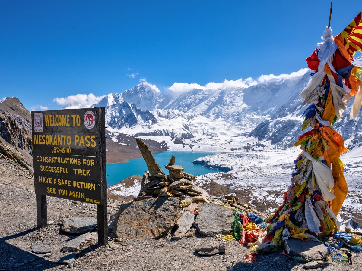
For starters, it takes you to less crowded, off-the-beaten-path regions of the Annapurna region, giving you a more authentic and peaceful Himalayan experience. You’ll cross Mesokanto La Pass (5,245 m), one of the most challenging yet rewarding passes, and enjoy spectacular views of the Annapurna range, Tilicho Peak, Dhaulagiri, and Pisang Peak.
Along the way, you’ll pass through traditional villages like Manang, Khangsar, and Siri Kharka, where Buddhist culture thrives with chortens, stupas, and prayer flags. You’ll also see alpine lakes like Tilicho, deep gorges, suspension bridges, and wild landscapes that feel untouched. This trek perfectly balances adventure, scenery, and cultural discovery, making it a truly unique journey in Nepal.
Mesokanto La Pass is not only physically demanding but also technically challenging. Some sections are remote with unclear trails, requiring careful navigation and the support of an experienced guide.
The crossing is highly weather-dependent, and in poor conditions, the route can become unsafe or difficult to follow. In such cases, alternative routes via the Annapurna Circuit, including Thorong La Pass, may be considered for safety.
But the views from the top, wide valleys, jagged peaks, and distant lakes make every step worth it. Crossing this pass is a real sense of achievement that stays with you long after the trek.
When you trek with Himalayan Ecstasy, you’re not just following a trail, you’re traveling with a team that knows the mountains inside out. We have experienced guides, reliable local staff, and proper equipment, so you can focus on enjoying the journey. Safety is our top priority, especially on challenging days like crossing Mesokanto La Pass.
We also support local communities, so your trek benefits the villages you visit. With us, you’ll get personalized guidance, real-time advice on weather and trail conditions, and insider tips on the best viewpoints, cultural spots, and hidden gems along the route. You are not just a trekker, you are part of our team.
The trek starts with a drive from Kathmandu to Besisahar, followed by scenic drives and treks through the Annapurna region villages. You gradually climb through Chame, Pisang, and Nawal, reaching Manang for acclimatization.
From there, you journey toward Siri Kharka and Tilicho Base Camp, before hiking to Tilicho Lake and moving to high camp for the Mesokanto La Pass crossing. After the pass, the trail descends through Nama Phu to Jomsom, where you can rest and enjoy better facilities. The adventure concludes with a flight or drive to Pokhara, giving you time to relax and celebrate your journey before heading back to Kathmandu.
Majestic Mountain Views That Take Your Breath Away
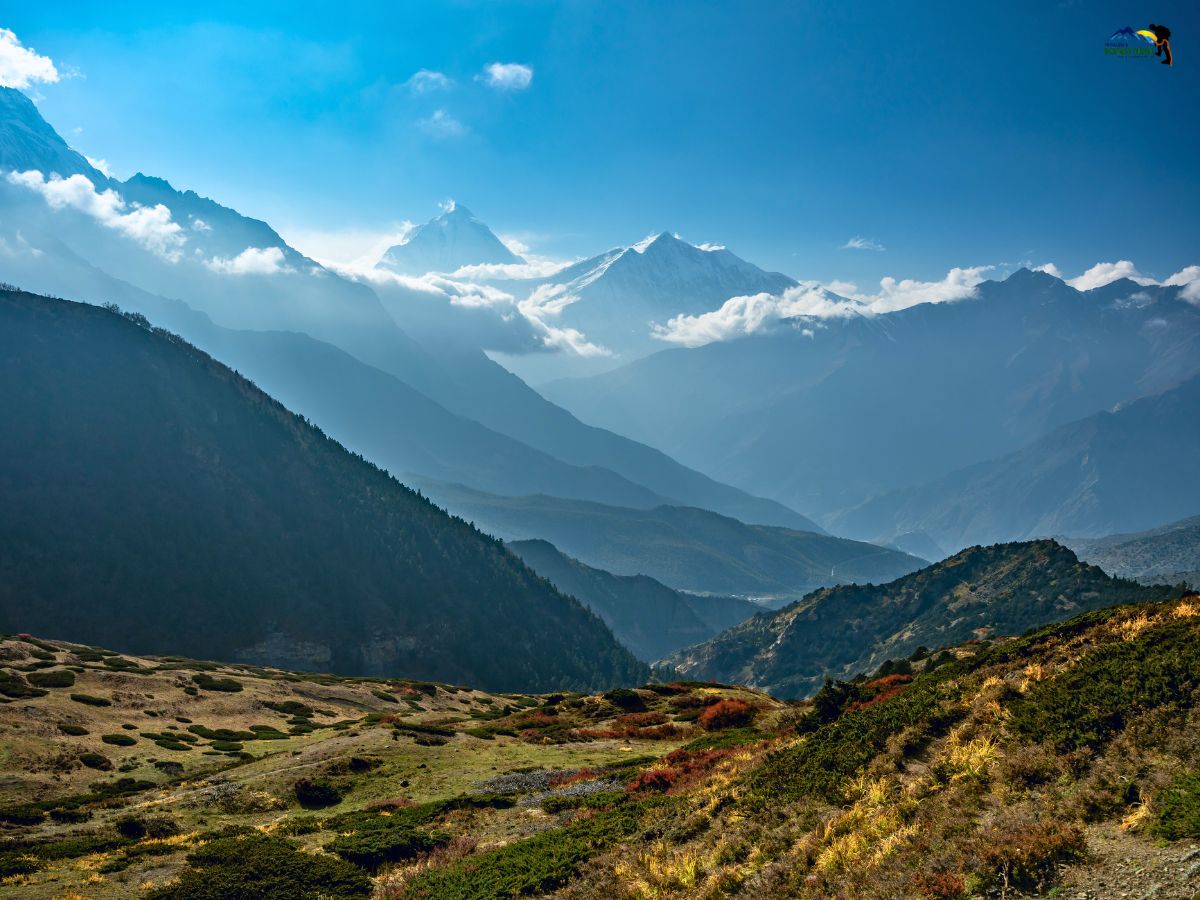
As you walk toward Mesokanto La, you’ll see mountains that feel endless. Snow-capped peaks like Annapurna I, II, and III, Tilicho Peak, Dhaulagiri, and surrounding ridges surround you from every side.
Early mornings bring crisp air and clear skies, perfect for taking photos or just pausing to soak it all in. Walking here, you feel like the mountains are alive, and every step reveals a new angle or hidden valley.
Tilicho Lake: Serenity at the Edge of the World
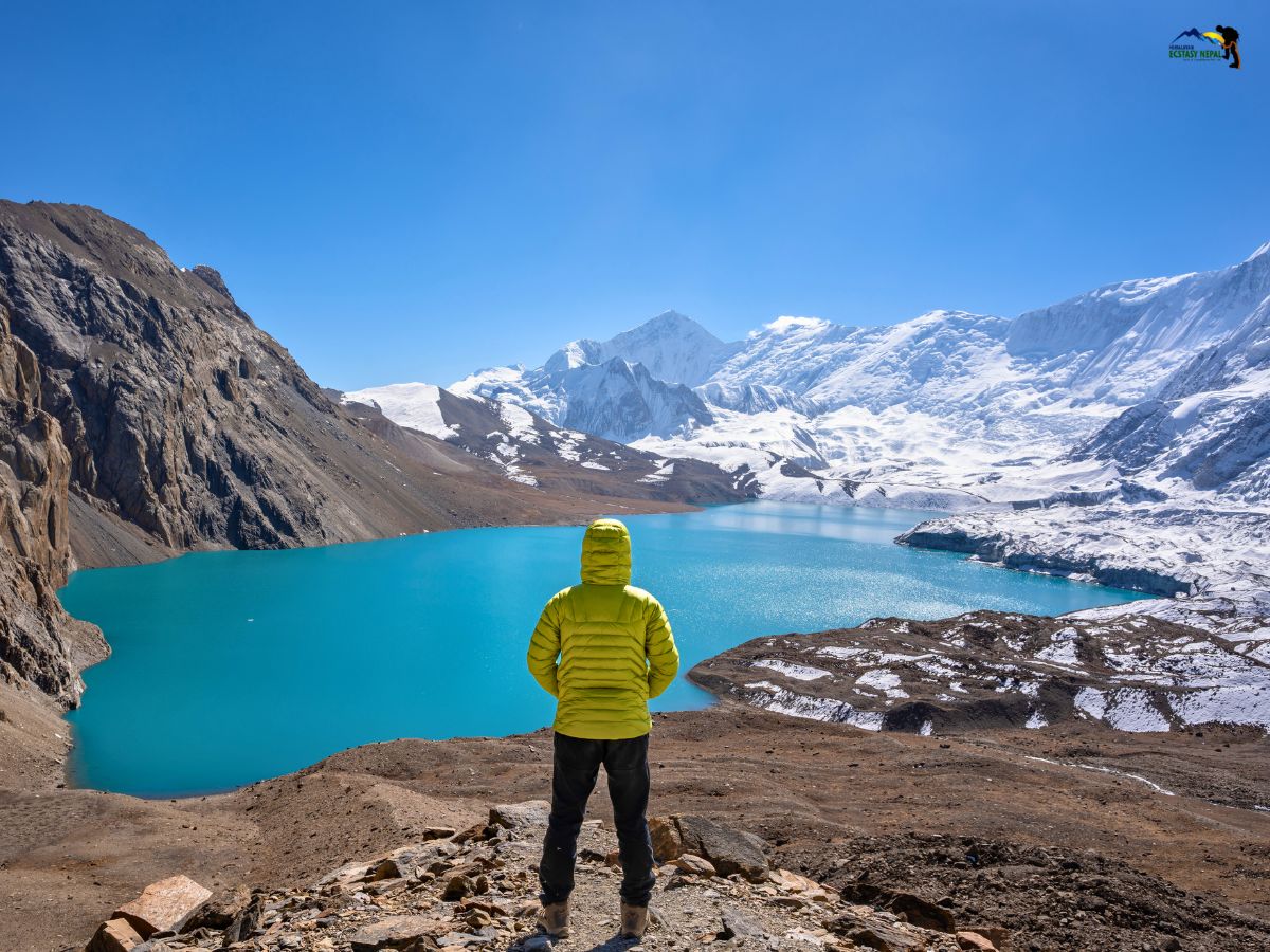
Hiking to Tilicho Lake is one of the most magical parts of this trek. The lake sits quietly at 4,919 meters, reflecting the surrounding peaks. The walk is steep at points, and the air is thin, but reaching the lake is incredibly rewarding.
Sitting there, surrounded by silence and snow, you feel completely apart from the world. This is a place to pause, breathe, and just take in the calm energy of the mountains.
Life in the Villages: Feel the Heart of the Himalayas
Moreover, this Tilicho Lake with Mesokanto La trek is not just about mountains and villages, it’s about discovering hidden corners of the Himalayas. Remote trails, quiet valleys, and high passes that few trekkers take make this trek special.
Every day offers something unique, whether it’s a hidden viewpoint, a crystal-clear stream, or a peaceful campsite. You feel like an explorer, not just a visitor!
Along the route, you’ll pass through quiet villages like Manang, Khangsar, and Nama Phu. Here, life moves at a slower pace. You’ll see people tending fields, prayer flags fluttering in the wind, and chortens marking sacred spots.
Our HEN guides will help you understand local traditions and customs, like walking past mani walls with respect. These villages give you a sense of connection to real mountain life, far from the usual tourist trails.
Camping Under the Stars: A Night to Remember
After crossing Mesokanto La, some sections require camping. Our HEN team sets up tents, sleeping mats, and warm meals. Sleeping under the stars at this altitude is an experience you won’t forget.
The silence, the cold night air, and the feeling of being completely surrounded by mountains are magical. It’s also a chance to bond with fellow trekkers and appreciate the quiet beauty of high-altitude life.
Wildlife and Flora: Nature’s Hidden Gems
The region is full of surprises for nature lovers. Along the trail, you may spot Himalayan tahr, blue sheep, or colorful mountain birds.
Forested valleys and alpine meadows show off rhododendrons, wildflowers, and pine trees, changing with the season. Walking here, you feel connected to a world that has remained largely untouched, where every corner reveals something new and unexpected.
Tilicho Lake and Mesokanto La Pass Trek in 14 Days Itinerary
Kathmandu to KathmanduExpand all
You arrive in Kathmandu, and our HEN team will be there to pick you up from the airport. We transfer you to your hotel in Thamel. After a long flight, today is for rest. You can relax, walk around a little, or just enjoy the vibe of the city.
In the evening, we will meet you for a short briefing. We explain the journey, road conditions, and what to expect in the next few days. If you need anything last-minute, we can help you arrange it.
Today, your journey really begins. You drive from Kathmandu to Besisahar, which takes about 6-7 hours. The road is mostly smooth at first, then a bit bumpy in some parts.
We stop on the way for light snacks, tea, and washroom breaks, so don’t worry about the long drive. The vehicle depends on your group size. If you are 2 people, we use a car. Around 5 people, we use a jeep. For bigger groups, we arrange a Hiace. If you are on a budget, we also have a sharing bus option.
During the drive, you will see many khola, nala (rivers and streams), small local markets, and sometimes even distant mountain views. You’ll also get your first feel of real Nepali life, kids walking to school, people working in fields, and simple village life. It’s a beautiful and eye-opening day.
By evening, you reach Besisahar and rest for the night.
After breakfast, you continue your journey by sharing a jeep toward Chame. Even though the distance is not very far, it takes around 5–6 hours because the road is rough and off-road (kacchi bato).
The ride is a bit bumpy but also very exciting. You pass through waterfalls, forests, narrow roads, and deep river valleys. Slowly, you start gaining altitude, and the air feels cooler and fresher.
Today is your first full day of trekking, and you walk for about 6 to 7 hours. The trail goes through beautiful pine forests, and the whole place gives a kind of European vibe with fresh air and birds singing.
Along the way, you’ll see yaks and mule caravans carrying goods for local markets. Small shops are available, so you can buy basic things if needed. You also get great views of Lamjung Himal, the Annapurna range, and Pisang Peak.
Today, you will walk for about 6 to 7 hours towards Nawal via Gheru.
The trail starts easily as you walk along the valley near the river. The area is wide and open, almost like a plateau. After about an hour, you cross a suspension bridge. From here, the trail becomes steep as you climb up towards Gheru.
We usually stop at Gheru for lunch. After your break, it takes around 2 more hours to reach Nawal. We chose this route especially because it gives you some of the best views of the Annapurna Range, including Annapurna I, Annapurna II, Annapurna III, and the Tilicho side mountains.
The views from this part of the trek are wide and very beautiful. You can clearly see the big snow-covered mountains and enjoy the peaceful landscape. Nawal itself is a very nice place to stay, and most clients feel really happy walking here because everything looks so open and beautiful.
If you want, there are optional side trips like going toward Nar Phu via Kang La Pass, which is more expensive and suited for those interested in remote areas or peak climbing like Chulu Far East. This area has a strong Buddhist culture, with many chortens and stupas. It is important to walk keeping them on your right side (clockwise) as locals believe it brings respect and good luck.
Today is a shorter day, around 3 hours of walking. The trail is a bit steep at first, but manageable, and even if you walk slowly, you’ll reach it early. Manang is a big and developed settlement, almost like a small trade center in the mountains.
You can find good lodges, bakeries, cafes, and even things like hot showers, but you have to pay extra for better facilities like internet/wifi. This is also an important acclimatization place.
You can visit the HRA center for advice or do short hikes to nearby spots like Gangapurna Lake and viewpoints. You can also try local Sea buckthorn juice here; it is a specialty of this area.
Sea buckthorn juice is a special local drink made from small orange berries. It is slightly sour and very refreshing, and many trekkers enjoy it for its energy and health benefits.
Today, you leave Manang and move towards the Tilicho side. The walk takes about 4 to 5 hours. The trail is narrow in some parts, but the views along the way are really beautiful.
As you walk, you can see amazing views of the Annapurna Range. You will also see Pisang Peak from the backside, along with other surrounding peaks like Dharke. In some sections, the trail goes through a deep gorge, which makes the walk more interesting.
The path is not too difficult, but it is best to walk slowly and steadily. Most trekkers stop at Khangsar village. But we try to take you further to Shri Kharka because the views from there are better.
First, you reach Khangsar and check the lodge situation. If rooms are available at Shri Kharka, we will continue walking and stay there. If not, we stay at Khangsar. Our guides will always choose the best option for your comfort and safety. Either way, you will get good rest and be ready for the next day.
Today’s walk is about 4-5 hours, but it feels a bit more challenging than previous days. The trail is narrow, rocky, and has steep uphill sections (we call it 'ukalo', get used to this term).
Even though the trail is a bit tough, the scenery is very beautiful with mountain views and quiet surroundings. Slowly, you reach Tilicho Base Camp, where you stay overnight.
Today is one of the most special days of your journey. You start early and hike for about 3 to 4 hours to reach Tilicho Lake. The trail can be a bit challenging, but the experience is truly worth it.
Tilicho Lake is one of the highest lakes in the world. The place feels very quiet and peaceful. You can spend some time here, take photos, and enjoy the wide mountain views around you.
After enjoying the lake, instead of returning to base camp, you continue moving towards high camp (Tilicho High Camp or Mesokanto Pass Base Camp). This helps you get closer to the route for crossing Mesokanto La Pass.
At the advanced high camp, we set up a light camping stay for 1 to 2 nights. We carry the basic equipment needed for this. Because of this, we have a few extra porters to support the team.
Today is the most important and challenging day of your trek. You start early from high camp after a light breakfast and begin your gradual ascent toward Mesokanto La Pass.
The climb is demanding, taking you across rocky, icy, and sometimes snow-covered terrain. Due to the high altitude, it is very important to maintain a slow and steady pace while following your guide closely.
After reaching the pass, you are rewarded with wide panoramic views of the surrounding Himalayan ranges, making all the effort truly worthwhile.
From the top, the descent begins and this section requires extra caution. There are steep downhill stretches, including rapid drop sections, along with loose scree and unstable terrain. Careful footing is essential to avoid slips or injury.
The trail in this section is very remote, and in some areas, it is not clearly defined. This makes navigation difficult, especially in poor weather conditions. Having an experienced guide is absolutely necessary here.
You will continue descending toward the Nama Phu area, where you stay overnight at a basic campsite. Today's total distance will be about 13 to 15 km approx. that takes walking duration of about 8 to 9 hours!
Important Note:
Weather plays a critical role on this day. If conditions are not favorable, we do not proceed. It is always better to wait for a clear window rather than take unnecessary risks.
In case of heavy snowfall or poor visibility, there is a real risk of losing the trail, which can be dangerous in such a remote high-altitude environment. Your safety is our top priority, and all decisions are made based on real-time ground conditions.
If crossing the pass is not possible, we may return to High Camp and follow an alternative route via Yak Kharka, connecting to the Annapurna Circuit and crossing Thorong La Pass instead.
We strongly recommend carrying sufficient dry food for the day. Communication devices such as a satellite phone or walkie-talkie are highly recommended, as they can be life-saving in emergency situations.
Today is a more relaxed day after the long and challenging pass. You start from the Nama Phu area and walk for about 5 hours towards Jomsom. The trail is mostly downhill, which makes it easier after the previous day.
After such a long and tiring journey, you will finally get time to relax. You can sit, enjoy a warm coffee, and let your body recover. As you descend, the landscape slowly changes. It becomes drier, more open, and windy. You will clearly feel the difference from the Manang side.
Jomsom is a busy and important place in this region. It works like a main gateway for Muktinath and Upper Mustang. Because of this, you will find better facilities here compared to the higher villages.
There are good lodges, cafes, and comfortable hotels where you can enjoy a proper rest after the trek. The area is also connected by road, which makes it more developed.
You have two options for this day. You can either fly or drive to Pokhara. Flights are quick and offer beautiful views, but they depend heavily on the weather. If the weather is not clear, flights may get delayed or cancelled.
In that case, driving is a more reliable option. If you do not like long drives, you can break the journey and stay at Tatopani. Here, you can relax in a good hotel and enjoy the natural hot spring, which feels very nice after a long trek.
From Tatopani, you also have options to continue towards Ghorepani or connect to the Annapurna Base Camp route.
Today you drive back to Kathmandu by tourist bus, starting around 7:30 AM. The journey takes about 6-7 hours (around 200 km).
On the way, you’ll see rivers, hills, and local towns. It’s a comfortable drive and a nice way to end your trip.
Our Himalayan Ecstasy Nepal team will meet you and arrange your airport transfer depending on your flight time. But if you plan to extend your stay in Nepal and are looking for further trekking packages, our doors are always open for you!
On this last day, we will even drop you to the airport and say goodbye in a Nepali style. We are sure you will fall in love with Nepal, and we hope to see you again on your next adventure. Be sure to stay in touch and don’t forget to pen down a review!
Trip Cost Details
Includes
- Transfers to and from Kathmandu airport.
- 2 nights in a comfortable hotel in Kathmandu before and after the trek.
- 1 night in a comfortable hotel in Pokhara after the trek.
- 9 nights' accommodation in tea houses and 2 nights in high camps along the route.
- All required permits for Mesokanto La Pass and Tilicho Lake: Annapurna Conservation Area Permit (ACAP) and TIMS Card (if required).
- Licensed English-speaking trekking guide with salary and insurance included.
- Meals during trekking days (breakfast, lunch, and dinner).
- Tea/coffee during breakfast and dinner.
- Camping equipment and porter support at high camps for gear and supplies.
- All necessary logistical arrangements, including route planning and safety measures.
Excludes
- Costs for personal expenses on the trek
- Airplane tickets to and from Nepal
- Fees for the tourist visa to enter Nepal (you need two passport-sized photos)
- Personal travel and health insurance (which covers for emergency evacuation)
- Meals that aren't listed in the itinerary, like drinks, snacks, chocolate bars, and alcoholic/non-alcoholic drinks
- Hot showers, Wi-Fi, phone, and internet access
- Battery or high-power electric devices charging (in higher-altitude teahouses)
- Services for doing laundry in Kathmandu or Pokhara
- Your hiking gear, equipment, clothes, and personal hygiene stuff.
- Costs that occur because of natural disasters, bad weather, political unrest, or other things that are out of our control
- Any costs that come up because you choose to leave the trek early (not refundable)
- Tips for guides and porters (not required, but common and appreciated)
- Any service that isn't listed in the "Includes" section
Optional Extra Services:
-
Additional porter service: USD 280 per porter for two trekkers (carries 20–22 kg)
- Private jeep pick-up/drop-off: USD 380 extra
Essential Information
Best Time to Do the Tilicho Lake and Mesokanto La Pass Trek
The best time for the Tilicho with Mesokanto La Pass trek is spring (March-May) and autumn (September-November). During these months, the weather is clear, the mountain views are stunning, and the temperatures are comfortable for walking.
Spring brings blooming rhododendrons, while autumn offers stable skies and perfect visibility.
Avoid the monsoon (June-August) because of rain, slippery trails, and limited views. Winter (December-February) is very cold, and some areas may be covered in snow. For the safest and most enjoyable experience, plan your trek in spring or autumn.
Difficulty Level of this Trek
The Mesokanto La Pass trek is considered challenging and is best suited for trekkers who are comfortable with high altitude and long walking days. Here's the brief:
- High Altitude: The trek reaches its highest point at Mesokanto La Pass (5,245 m). Proper acclimatization, especially around Manang, is very important to reduce the risk of altitude sickness.
- Physical Fitness: You need a good level of fitness and stamina. Most days involve 5-7 hours of walking, and on the pass day, it can go up to 8–9 hours. The trail includes steep climbs, descents, and uneven terrain. Previous trekking experience is helpful, but fit and prepared trekkers can also complete it.
- Trail Conditions: The trail passes through narrow paths, rocky sections, loose scree, and high mountain terrain. Some parts, especially near the pass, can be remote and less defined, so careful walking is needed.
- Technical Skills: This is a trek, not a climb, so no technical mountaineering skills are required. However, using trekking poles is very helpful. In colder months, there may be snow or ice near the pass, where basic gear like microspikes can be useful.
Permits Required for This Trek
To trek in the Mesokanto La Pass area, you need a few official permits:
- Annapurna Conservation Area Permit (ACAP): Needed for trekking in the Annapurna region. Helps protect nature and supports local communities.
- TIMS Card: Standard trekking permit for safety tracking (for both guides and trekkers, but it has become optional these days).
Our Himalayan Ecstasy Nepal guide will arrange all permits for you. They will keep them safe on your behalf and show them at checkpoints along the trail when required. You need not to take any hassle!
Tip: Always follow local rules and show respect. It keeps you safe and helps preserve the culture and environment.
General Expectations on Tilicho Lake and Mesokanto La Pass
- Accommodation: During the trek, you will mostly stay in local teahouses and lodges. These are basic but comfortable, usually with twin-sharing rooms. In places like Manang, you may find better rooms and facilities.
- Food: Food is simple but good. You will mostly eat Dal Bhat, noodles, soup, eggs, and similar meals. It gives you enough energy for long walking days. In bigger places like Manang, you can also enjoy some bakery items and coffee.
- Drinking Water: Safe drinking water is very important. You can get boiled water at lodges, or use purification tablets or filter bottles. We always suggest you drink plenty of water to stay hydrated at high altitude.
- Communication: Network is not always reliable. In some places, you may get Wi-Fi, but it is slow or paid for. So it’s better not to depend on the internet during the trek.
- Cultural Experience: This trek gives you a chance to experience real mountain life. You will walk through villages with Buddhist culture, monasteries, mani walls, and prayer flags. The region has a strong Tibetan influence, especially around Manang and Khangsar.
- Adventure & Trail Experience: This trek is more for adventure seekers. The section from Tilicho towards Mesokanto La Pass is remote and less crowded. We usually set up light camping near the lake (west side) before crossing the pass. The next day is long, taking around 8–9 hours to cross Mesokanto La. From the top, you get 360-degree mountain views, and in good weather, you can even see beautiful reflections near the lake. After crossing the pass, the trail is steep and slippery at first, so you need to walk carefully. Good warm clothes and proper gear are very important. In some conditions, microspikes or crampons are helpful. After descending around 200 meters, the trail becomes easier.
- Customisation Options:
- From Manang, you can do extra hikes like Ice Lake (Gangapurna viewpoint area).
- Takes around 5–6 hours to go up and 3 hours to return
- You should carry a packed lunch
- We can adjust the plan based on your time, fitness, and interest, whether you want more adventure or a more relaxed experience.
Safety Note: For this trek, we strongly recommend having travel insurance that covers high altitude and emergency evacuation. Conditions can change quickly in remote areas, and safety always comes first.
Equipment Lists
We all know that proper preparation is essential for trekking in the Himalayan region. And when it comes to the Tilicho Lake and Mesokanto La Pass Trek, you're going to reach high altitudes and pass through remote mountain areas. Hence, every trekker must be responsible in carrying suitable clothing, equipment, and other personal items. These are for yourselves, so you stay safe and comfortable throughout the high-altitude, rugged adventure. And for your comfort, here's what the experts at HEN have to say about the equipment list that you will require for a successful trek (even if this is a budget trip):
Head
- Sun hat (wide brim or cap) for protection from strong sunlight
- Warm beanie or fleece hat for cold temperatures
- Buff / neck gaiter for wind, dust, and cold protection
- Headlamp with extra batteries for early morning trekking or night use
- Sunglasses with UV protection to protect eyes from strong sunlight at high altitudes
Upper Body
- Lightweight liner gloves for mild cold conditions
- Warm fleece or softshell gloves for trekking in colder areas
- Waterproof insulated mittens for very cold temperatures at high altitude
Hands
- Thermal base layers (2–3) to keep the body warm and dry
- Fleece jackets for insulation during cold weather
- Waterproof and windproof jacket for protection from rain and snow
- Down jacket for very cold conditions at higher altitudes
- Lightweight trekking shirt (long sleeve recommended for sun protection)
Lower Body
- Thermal leggings or base layer pants for warmth
- Trekking trousers (1–2 pairs) made of quick-dry material
- Softshell trousers for higher altitude trekking
- Waterproof rain pants for protection during rain or snow
- Comfortable trekking shorts (optional for lower altitude sections)
Foot Wear
- Waterproof trekking boots with strong ankle support
- Camp shoes or sandals for resting at teahouses
- Trekking socks (3 to 4 pairs) made of wool or synthetic material
- Liner socks (optional) to prevent blisters
- Gaiters for protection against snow, mud, and small rocks
Travel Documents
- Passport and Nepal visa
- Travel and medical insurance
- Airline tickets or e-tickets
- Passport-size photos for permits
- Cash (Nepalese rupees) and credit/debit cards
- Copies of important documents
Sun Stuffs
- Sunscreen with SPF
- Lip balm with SPF
Toiletries
- Toothbrush, toothpaste, and biodegradable soap
- Moisturizer and hand sanitizer
- Quick-dry towel
- Toilet paper and wet wipes
Eating & Drinking
- Energy bars or granola bars
- Nuts and dried fruits
- Chocolate and trail mix
- Crackers or biscuits
- Electrolyte powder or energy drink mix
Sleeping Bags
- Warm sleeping bag with a rating of -10°C to -15°C for cold nights at higher altitudes
- Sleeping bag liner for warmth and hygiene
- Compression sack or waterproof bag to keep the sleeping bag dry during the trek
- Tents (will be provided on a sharing basis)
Bag Packs
- Main trekking backpack (40-60L) for carrying personal gear during the trek
- Daypack (20-30L) for carrying essentials such as water, snacks, camera, and extra clothing
- Rain cover for the backpack to keep gear dry in rain and snow
- Dry bags or waterproof stuff sacks for keeping gear dry
Medical & First Aid
- Diamox (Acetazolamide) for altitude sickness prevention
- Paracetamol or Ibuprofen for headache, pain, or fever
- Anti-diarrhea medication (Loperamide / Imodium)
- Oral Rehydration Salts (ORS)
- Antibiotics (if prescribed by your doctor)
- Anti-nausea medication
- Cough and cold medicine
- Throat lozenges
- Antihistamines for allergies
- Blister treatment (Compeed / moleskin)
- Antiseptic cream or wipes
- Adhesive bandages (Band-Aids)
- Elastic bandage for minor sprains
- Personal prescription medications
- Water purification tablets or drops
Miscellaneous
- Trekking poles help you stay steady and put less strain on your knees.
- Water bottles or hydration bladders that can be used again
- Tablets for cleaning water or a water filter
- Headlamp with extra batteries for early mornings or late nights
- Sunglasses that block UV rays
- Sunscreen with an SPF of 30 or higher and lip balm with an SPF
- Towel that dries quickly
- Toiletries and hand sanitizer for personal use
- Power bank for charging gadgets